Nahal Lachish is a mostly dry river, with water flowing primarily during heavy rains.
Its main tributaries are Nahal Lachish, Nahal Gubrin, Nahal Hala, and Nahal Barqai. The river originates in the western regions of the Hebron Mountains and flows into the sea in the Ashdod area.
Nahal Lachish, like most Israeli rivers, is a seasonal river, meaning that water flows in it only after heavy rains. However, its end, the part that flows into the sea, remains wet throughout. The river’s estuary is called an estuary, and its length in Nahal Lachish is about two kilometers.
The various tributaries of Nahal Lachish start in the southern regions of the Judean Mountains, on the western side of the mountain range. These converge into four major rivers (Nahal Gubrin, Nahal Hala, Nahal Barqai, and Nahal Lachish). The first three join Nahal Lachish not far from the Lachish junction, heading south to north at the entrance to the southern city.
If Nahal Lachish is a seasonal river, how does its estuary remain wet all the time?
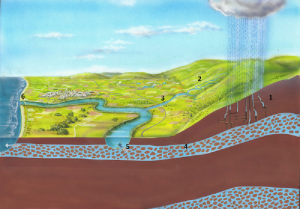
The flow of water in rivers occurs in two layers, the visible layer that we see and the layer beneath the ground that is hidden from our eyes. The river is fed by rainwater and is also fed by both surface flow and hidden flow.
The water that flows above the ground comes from the mountains, so in the summer, after the rains have stopped and there is no more water coming from above, the river dries up (hence the name seasonal river). In contrast, rainwater that percolates into the ground and flows through a permeable layer called an aquifer flows more slowly, so it takes longer to reach the end of the river, the estuary. Because in different places the riverbed’s slope is lower than the surrounding ground surface, aquifer water can seep from it into the river and fill the part that we see as wet throughout the year.
But that’s not all…
Just as seawater flows into the river, there is also seepage of seawater into the river due to changes in the water levels in both the river and the sea. As we know, water flows from a higher place to a lower place.
The entry of very salty seawater into the river creates a mixture of waters and makes the water at the river’s estuary (which was sweet) become salty, meaning it is salty but not as salty as seawater.
And of course, even above the river’s estuary, more rains fall and directly fill it.
Infiltration of rainwater into the subterranean layer
Beginning of water flow in rivers from the mountain range (highland)
Flow of water in the visible river layer
Flow of water from beneath the ground in the hidden aquifer from the river
Seepage of water from the hidden aquifer from the river into the visible river layer
River estuary: River water flows into the sea, and seawater infiltrates into the river
Question: What are the sources of water in the river?
This project was established with the support of the Ministry of Environmental Protection, the Union of Environmental Quality Cities, and the Municipality of Ashdod.